Engineering Geology for the Snowy Mountains Scheme
The granite is closely jointed, with an average spacing of 6 inches to 1 foot. Several narrow sheared zones have been observed within the dam site, usually a few inches or less in width.
No large-scale faulting has been found within the dam foundations or spillway area, but immediately upstream where the valley widens there is a major fault zone. The faulted rock does not outcrop, but the fault was detected at an early stage in the investigations from a study of aerial photographs and of the topography. Its presence was indicated on the right bank by a narrow depression filled with scree; in the valley bottom by the unusual widening of the river valley with alluvial flats ; on the left bank by a soil- and scree-filled depression leading up into a low saddle. All these features were along one line which continued southwards along a prominent creek with much swampy ground and springs. The fault zone was extensively explored by diamond drilling, bulldozer and hand trenching, shaft and drives, and seismic refraction surveys.
The downstream edge of the faint zone is a very well defined fault plane, which crosses the river at right angles and dips steeply upstream away from the dam. Upstream of the fault plane is a zone of crushed and sheared granite with many clay seams, about 300 feet wide at river level, but narrowing as it is followed north. Downstream of the fault plane there is a sharp change to the jointed but otherwise sound rock of the dam site.
The presence of the fault zone, together with deposits of very loose scree, consisting of granite fragments with a little interstitial soil, up to 50 feet in thickness filling the depression eroded in the fault zone,
very considerably restricted the sites available for the intake of the T.1 Pressure Tunnel.
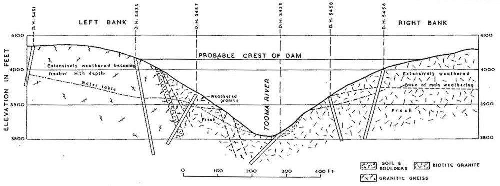
Tooma Dam Site.
—A site has been investigated for a flood storage dam 220 feet high on the Tooma River, 10 miles south-west of Cabramurra. A section through the dam is shown in Fig. 4. The rock forming the right abutment, the river bed and lower left abutment is grey biotite granite; while the remaining part of the left abutment is granitic gneiss. The granite is intrusive into the gneiss. The granite exposed at river level is practically fresh, and on the abutments it is solid and not much affected by weathering up to 70 to 110 feet above river level. Above this on the right abutment it develops a completely and highly weathered layer which increases in thickness going up the bank to a maximum of about 100 feet. Below this layer there is a rather abrupt change into fresh granite. On the left abutment the granite is weathered in a similar fashion. The gneiss occurring in the higher part of the left abutment and as lenses in the granite is weathered to greater depths than the granite, but the weathering is more gradual and progressive, and there is relatively much more moderately and slightly weathered and less completely weathered rock. The gneiss shows some moderate weathering 200 ft. below the surface, and some slight weathering 250 feet down.
Because of the deep and extensive weathering the site is unsuitable for a concrete dam, and an earth and rock fill dam is being designed. For the foundations of the main part of the embankment it is expected that only stripping of the slope wash soil and disturbed uppermost part of the weathered rock, a few feet in all, will be required.
